|
[Course]
OtaruüĘSapporoüĘTakikawaüĘHuranoüĘBieiüĘAsahikawaüĘShibetsuüĘ HaboroüĘSarobetsuüĘWakkanai
(About 800km, 11days)
[Report]
This is my first long touring.
The side way in Hokkaido is much wider, it is easy to run. People
who ride on a motorcycle or car wave their hands when they pass
me by.
At Hurano, the lavenders are in full bloom. Here is the best place
to ride on a bicycle. The pictute in the first page is the lavenders
in full bloom. Though you do not like riding, I sure you feel
confortable to run.
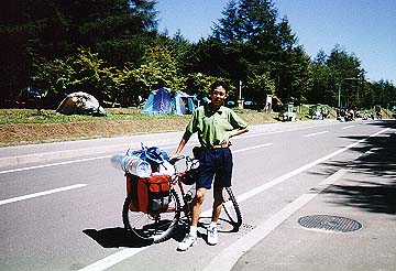
This picture shows that I am about to go to Biei in the morning
after I put a tent away.
Biei is famous for a beautiful landscape of hill. When you make
a tour around hills, you are surprised to see their grandeur,
and you will think that such scenery is rare in Japan. And the
sun disappearing behind the hill is also good.
There are many meadows near Wakkanai. I do feel I am in Hokkaido.
From Haboro to Wakkanai, it rains. I feel very cold in spite of
middle summer.
At Souya cape, Women at middle age who come here by bus are moved
by me ,because I make a tour by bicycle. So I become a popular
person soon !!
(I am striking when I make a tour by bicycle.)
 |
[Course]
TakayamaüĘHirayu SpaüĘAbo PassüĘ(Via Kamikochi-Norikura Super Mountain
Road)üĘShirahone SpaüĘNorikura PlateauüĘMt.NorikuraüĘKamikochiüĘMatsumoto
(About 300km, 5days)
[Report]
This time, my distination is Mt.Norikura, which we can go up to
the highest point by car in Japan(2702m).
On the way, there are excellent spa like Hirayu, Shirahone. These
are suitable for a lover of spa, as me.
There is the open, lush green camping site at Norikura Plateau.
Also, there are pasture and walking road, so I recommend you to
going for the summer.
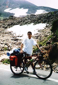
This picture shows the Large snowy valley, along the road up to
Mt.Norikura. You can see summer-skier on it. To tell the truth,
my face is drawn a little, because I repeat ride on and off many
times until I reach this point!!
After I arrive at the highest point for car, I leave my MTB there
and climb the mountain,then reach the top(3026m). From there,
I can view very good scenery.
At Kamikochi, asightseers comes much. You can enjoy fully if you
camp along Azusa River.
 |
[Course]
My homeüĘWakayama PortüĘ(Ferry)üĘKomatsushima PortüĘTokushimaüĘAwa-IkedaüĘIya
valley (Kazura Bridge)üĘKobokeüĘKochiüĘKatsurahamaüĘNakamura (Shimanto
River)üĘAshizuri CapeüĘSukumoüĘUwazimaüĘOzuüĘMatsuyama (Dogo Spa)üĘ(Ferry)üĘBeppuüĘYuhuinüĘ(Yamanami
High Way)üĘMt. Aso
(About 1000km, 14days)
[Report]
This touring is wayward (evey touring is so, but this time, especially).
Every morning, after I have a breakfast, I decide the distination
of the day. What I decided initially is
As far as Kochi, it all rains. Especially, when I run in the mountain
I feel miserable because of the rain.
Near Katsurahama, I feel as if I were in a south land. I go a
monotonous waterfront road, but I am able to be plesant to run
slowly.
On the way to Ashizuri cape, I take the wrong way, Skyline. The
road locates along the top of the mountain, so it takes much time
to go to Ashizuri cape than I go the waterfront road.
Matsuyama is much larger city than I expected. But the city is
beautiful and makes me feel a good point of a locality. I stayed
2 days there because I was satisfied with Dogo spa.
Yuhuin is famous for art museums and spas. I like this town because
it is a simple spa town,not a large. When I stay at Yuhuin Youth
Hostel, I feel a homey atmosphere, and its building is fine. Besides,
a night view seen from there is beautiful, do come here.
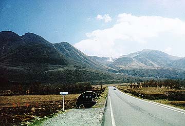
There are many meadows as far as Mt. Aso, so they remind me of
Hokkaido. Mt.Kujyu is grand. This picture shows near Mt.Kujyu.